
Recentering Detroit is a multipart examination of culture of development in the current city, the ongoing crises and the efforts by residents to define their city, not as a relic of the past to be resurrected or “revitalized,” but a place where people live their lives. This examination will be made within multiple contexts, including race, racism, the complex histories of Detroit, infrastructure and economics. Click to read: Part 1: Against Revitalization.
by Michael Stepniak
As Detroit grew, it annexed the towns and villages around it. The city that exists today grew by gradual annexation. The site Detroitography has a graphic that shows the city’s footprint changing over time. It comes to a halt in 1926.
Just because the borders of the city proper remained static after 1926 does not mean Detroit did not grow. It filled up and spilled far out into suburbia and the countryside, in a process of development that is still ongoing.1
It took two centuries after European contact for Detroit to become a big city. It happened slowly at first, starting from Cadillac’s landing and a fort that measured a single arpent. The city’s population and area growth accelerated over the decades, until it wasn’t just the city proper, but an entire metropolis of many people and governments.
This is not a process that can be replicated. Detroit isn’t downtown anymore. It is a big, messy city surrounded by a big, messy metro area (Fig. 1). The neighborhoods around downtown are not at the center, and the city limits are not the periphery. The last time we tried this, it took a long time, and Detroit was undeveloped. Now, the geography of Southeastern Michigan has changed: the processes of urbanization are uneven, not linear, and not springing from the radial arms of downtown. The city needs to be connected within itself and with the suburbs at multiple points, not an all-roads-lead-to-downtown system.
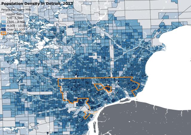
Figure 1: The Big, Messy Metropolis. Data Attribution: U.S. Census, 2013 ACM 5-year estimates
Bill Hubbard begins “American Boundaries: The Nation, The States, The Rectangular Survey” with an anecdote. Hubbard visits the Michigan Museum of Surveying in Lansing. At the gift shop is a poster of Mt. Rushmore that is captioned “Three Surveyors and the Other Guy.” Washington, Jefferson and Lincoln were all surveyors, a fact that, as Hubbard notes, undoubtedly informed their visions for the country. Hubbard writes that the poster hints “that the United States is a nation formed by surveyors, people whose chief task is marking borderlines upon the land that cleanly apportion its surface into discrete parcels, each destined to be the sole property of some identifiable person, entity or government.” This parcel is called a cadastre: “a perfect, no-conflicts allotment of the earth’s surface – not just on maps but upon the land” (Hubbard ix).
Hubbard writes of two cultural conditions that existed in the United States soon after independence. The first was a feeling that North America was a blank slate, and that Americans were its masters.2 The second was a reaction to Europe. Hubbard writes: “recent Americans arrived from a Europe where boundaries had seemed as inevitable as facts of nature but drawn to the advantage of the powerful” (x). Most Americans, as British subjects, could never hope to own land. Although the British middle class did exist (Benjamin Franklin came from one such landowning family of non-noble lineage), the largest portions were occupied by those born owning it (Isaacson 5).
Hubbard says that “from the first, we felt impelled to know, with certainty, the exact location of the boundary between ‘what is mine’ and ‘what is somebody else’s’” (x). Land became an instrument of democracy in certain ways. One was the right to vote. In the century following independence, the right to vote was restricted in many states to white male property owners. Under these rules, democracy would be expanded if property was easier for white males to attain. Other aspects of the relationship between land and democracy are that of what to vote for, what to identify with and what issues matter. The point of view that one takes often depends on which side of a border a person is on.
Hubbard writes that “to an American it doesn’t matter, too much, what the provenance of a boundary is. Where else but in the United States could citizens feel an intense identification with entities called Colorado and Wyoming, whose boundaries are mere rectangles… drawn indiscriminately across mountains and plains?” This identification is physical and emotional, as well as practical. Hubbard observes that the things that change when passing through different states: license plates, odd names for familiar things, accents, architecture and so on.3 These are physical and emotional things. There are other things that mater, that signify home (x). A Pennsylvanian driving home from Ohio will notice the land becoming more mountainous, and will feel that sense of home. The Ohioan will likely feel the same when noticing the land becoming flat again.
The practical aspects are the laws that govern the Pennsylvanian and the Ohioan. Despite their proximity and, in many ways, their similarity, Youngstown, OH and Erie, PA identify with their rectangles partly because of the things that matter in their everyday lives: speed limits, highway funding, labor regulations, gasoline taxes and public schools.
Another set of emotions is in play between identity and home within these rectangles. Hubbard writes of seeing it from an airplane or an aerial map: “the great, gridded landscape… It is the quintessential American landscape, characteristic of us, emblematic of qualities we value and aspire to: plainness, sobriety, evenhandedness, evincing “good sense” as we reckon it. It is a landscape daunting in its implacability but, to some of us, both deeply moving and ineffably beautiful” (xi).
Over nearly two and a half centuries, groups of citizens in the United States have fought for an ever-expanded democratic enfranchisement.4 This is a legacy of American leadership before and after the revolution. The leaders of the American Revolution were powerful, landed men. All of them were white, many held other human beings in slavery, were outright rich, and some were perpetrators of Indian genocide. Yet they articulated a vision that took power out of their hands and put it with a larger population.
Because the right to vote was tied not only to being white, but to the ownership of land, land became the method of expanding democracy. Land would not be distributed in large tracts to the wealthy, as was the case in Europe. It would be made available to the general population of white males. Hubbard states:
We Americans decided, even before we were a nation, that unsettled land would not simply be thrown open to claimants to divide up as they chose, nor would the land be offered up for sale to the highest bidder. Instead, the national government would hold the land in trust for all the people, survey it into rectangular parcels, and make those parcels available to individuals and families (xii).
Hubbard writes that “to the originators of this Rectangular Survey, the system was merely an efficient, foolproof way of apportioning the public lands” (xii). It was more than that to Thomas Jefferson. This was an opportunity for the expansion of democracy, of a dissemination of power from the hands of the few to the many. Giving power to people had never happened in such a manner or on such a scale. It is unlikely that it will happen again. As Hubbard says,
Underlying the whole story is the very idea of lands being held in trust as public domain. At the time of our nation’s independence, all of its land, from the Atlantic west to the Mississippi, was under the jurisdiction of the thirteen new states… Gradually the idea arose that lands not yet settled should be held by the national government, parceled out to settlers, and eventually formed into new states… (xii)
The Rectangular Survey as a basis for the formation of new democratic states completed the idea of land as an instrument of democracy. Rather than exert colonial-style control over American territories, American leadership decided to put democratic power squarely with Americans. They knew, as rich businessmen, slave holders and entrepreneurs, that offering power to an ever-expanding number of citizens would often run counter to their interests. Still they put forth this vision of America and its democracy.
Jefferson was a person who thought in big, abstract strokes of idealism and genius.5 He was never able to scale his ideas down from ideal to practical application. He thought slavery was an extreme evil, yet he held slaves. He did a number of things along these lines. His position versus his actions regarding slavery extended to his actual practices as a slave holder. Jefferson had a strong belief that slaves at Monticello should not be abused or overworked, but since he was in debt and liked to spend money, he left discipline to an overseer and just didn’t inquire too much (Ellis 179). He believed that an agrarian life was the virtuous way. Yet he spent a good portion of his life in big cities from New York to Paris. He despised cities for their dirty factories, but upon returning home from New York, he had become fascinated and impressed by one such facility. Jefferson designed and built a nail factory on the plantation grounds, but did so out of sight of the main house (Ellis 168). Jefferson had an inability to integrate his big ideas and idealism with practicality. When he chose to be practical, he often did so without morality or empathy for others. It was almost inevitable that his proposals for the rectangular survey of America would be rejected. That said, Jefferson’s idea and ideals survived initial rejection and carried through into the more practical, real world application that resulted.
In 1784, Jefferson presented his idea for the survey of land, the creation of new states, and the spread of democracy across the continent. Jefferson’s initial concept was based on a new system of measurement that he had devised, similar to his successful effort to decimalize currency. The first and biggest new unit was that of a state: Jefferson’s states would be largely rectangular, and measure two degrees latitude from north to south, or 120 nautical miles (which Jefferson called Geographical Miles) (Hubbard 111).
The geographical mile became the basis for Jefferson’s new measurement system, an attempt to decimalize land in the new United States. His new principal unit of measurement was the Hundred. A Hundred would be a grid of 100 blocks of one square mile each, or ten miles per side. Each new state would measure twelve Hundreds from north to south, and be gridded east to west to fill out the new borders (Hubbard 183).
A Hundred was too large for a single farmer. Jefferson wanted each Hundred to be divided into, according to Hubbard, “a checkerboard of one hundred lots.” A lot would be one mile per side, or exactly 1,000 acres. Once Hundreds were surveyed, they would be put into squares of nine each called districts, so that four districts would fit perfectly into the north to south state measurement of 120 geographical miles (Hubbard 183).
Jefferson’s ideas for the execution of the survey were detailed and practical, which, coming from a former county surveyor is not surprising. He outlined techniques to be used and the timing of the surveys (Hubbard 187).
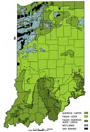
Figure 2: Big Data, the First Try. Data generated from the Rectangular Survey used to analyze indigenous plant life in pre-1800, pre-industrial Indiana.
Additionally, Hubbard writes, Jefferson’s plan stated that “as he ran the lines, the Surveyor was required to note the courses of any streams that crossed the line, as well as the positions of features like springs or salt licks that fell near it, and then record those features in his maps” (185). This, with several modifications, was an aspect of Jefferson’s vision that anticipated modern America: this is Big Data, the first try (Fig. 2). When the final survey was conducted, surveyors did record their observations into a grid (or a pre-digital spreadsheet). This data on what the continent was like in the pre-industrial era, from land cover to types of indigenous plant life is still available, has been digitized and is still widely used.
Hubbard writes that in 1784, “Congress took Jefferson’s plan for land disposition under consideration, sent him to Paris, and then soundly defeated it” (186). In 1785, Congress once again, reacting to pressures from the British, Indians and American settlers who were pushing west, took up Jefferson’s plan. This time, rather than rejecting it, they appointed a committee to, as Hubbard puts it, “come up with a course of action the whole assembly could endorse” (187) Hubbard writes that “Certain features of Jefferson’s grand, abstract vision managed to make it into the more modest, tough minded replacement” (187). These “certain features” were among the most radical ideas: the wealthy and powerful would distribute the wealth, power and democratic rights among a larger public, and the first large-scale data collection grid.
When deciding how land would be portioned out, Congress had to contend with issues that Jefferson’s abstract vision did not: conditions on the ground. Lands were ceded or not ceded by Indians, states engaged in border conflicts, parts of newly acquired territories were impossible to defend, and so on. In addition, certain lands were owed to veterans of the Revolutionary War, and as the United States was still a confederacy with no right to impose taxes, the sale of land had to be expedited to pay down war debts (Hubbard 184).
Jefferson’s Hundred was modified in committee into a smaller unit called a township.6 Each township would be a square, seven miles per side, divided into 49 one square mile parcels, which were renamed as sections (Hubbard 187). There was debate over how land should be sold, based on differing traditions in the north and south. Southern custom stated that an individual buyer would go to state authorities, purchase land and stake it out himself. In New England, a “proprietor” would purchase and develop a large area and then sell to individuals. Neither side wanted the other’s custom to dominate, so in the end they compromised and a checkerboard of both customs was decided upon (Hubbard 213).
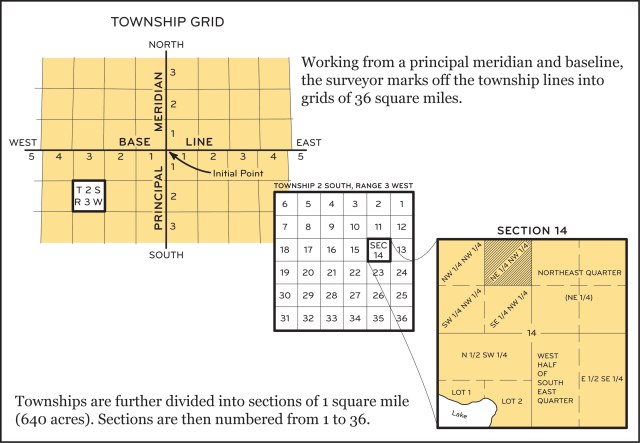
Figure 3: The end product: 36 square mile townships.
At the time, it had been decided that within each township, the center square would be reserved for the maintenance of public schools, and that each corner would be reserved for the Federal Government. Near the end of the committee’s process, the 49 square mile township was changed to a six mile sided square of 36 square miles (Fig. 3). The public school’s square was shifted off center, as the new township had no center square. The Federal Government’s reserved squares were brought in from the corners, so as to deprive the government of four contiguous square miles at the intersection of townships. Congress re-adopted Jefferson’s terminology of lots, replacing sections, and then later again decided to use sections after all, which continues to this day (Hubbard 193).
Jefferson’s vision, beyond democracy, the decentralization of power and wealth, and the collection of data was of an agrarian society of simple farmers, spread out thinly, so that each family or individual could live off their own land. His plan called for farmers to purchase lots of one square mile, which is far more than needed so as to rarely see a neighbor. Once again, practicality struck against him. The United States needed to raise funds, and despite favorable financing terms, sections were not selling fast enough. The method of subdivision of sections began evolving. In 1800, the half-section was introduced (320 acres), and in 1805, quarter-sections became available (160 acres). Soon after followed the half-quarter (80 acres) and the quarter-quarter (40 acres). Additionally in 1805, Congress decided that a section could only be divided along perpendicular lines (Hubbard 275). All this was done to make the sale of land more attractive and possible. Jefferson’s dream of spreading democracy was facilitated by the United States government’s need for revenue.
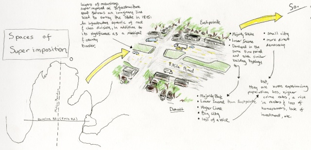
Because the Earth is a curved surface, maps must be projected. In order to accomplish this, a series of Meridians (lines of longitude) and Baselines (lines of latitude) were drawn across various regions. Daniel Jacobson writes: “for surveyors the greatest task was the delineation on the land of the Principal Meridian and Base Line” (131). Delayed by the War of 1812, the survey of Michigan began in 1815. The Michigan Meridian was defined by lands ceded by the United States government to the Anishinaabe. The Base Line was set by Jared Mansfield, the Surveyor General of the United States, who said it should “run a little north of Detroit” (Jacobson 132). The Baseline was set eight miles north of the city center along Woodward Avenue from where Michigan Avenue, or “zero mile” begins. When metropolitan Detroit adopted its “Mile Road System,” it became known as 8 Mile Road.
The superimposition of the Rectangular Survey of a grid, irrespective of the land, upon the American West changed everything.7 It accomplished Jefferson’s vision of the decentralization of power and the spread of democracy, to a point. With that superimposition came borders, and almost immediately with the creation of these borders, came competition, segregation, identity politics, differences of law and justice, and the accumulation of wealth within some borders at the expense of those who lived within another set of borders.
The placement of a political border is arbitrary, but the ecology of the border is not. The logic and ideology that led to the creation of a border may or may not be realized. Functionally, borders exist to divide one thing from another, and have racial, cultural and economic implications. 8 Mile Road is more than the border between Detroit and the northern suburbs. It is a wide boulevard occupied by speeding cars and semi trucks. It is physically difficult and at times dangerous to cross on foot. It is a big piece of infrastructure. More than a political border, it is a physical boundary. It is not quite a mountain, but more like a river with a dangerously fast current. In addition to these characteristics, it is locally infamous enough that the normally dignified Detroit Historical Society posts the following description of the road:
Along its most impoverished sections, Eight Mile Road has, for several decades, been a dangerous strip of suffering businesses and broken windows. It’s still a main artery for commuters and area residents – more than 1,500 businesses call Eight Mile home. However, it’s also not uncommon to find prostitutes, strip clubs and junkies patrolling the street at all hours.
There is animosity between residents on both sides of the border, due to racism, classism and the heavily politicized nature of the space.8
Peter Morris, writing of the Montana-Alberta border, states that “Canada’s own potent regionalism, combined with everyday cross-border interaction with neighboring states to the south, blurs the transnational divide into what might be described as a series of borderlands,” but also notes that U.S. Citizens are more likely to refer to the border as an “imaginary line,” while Canadians are “more sensitive to the significance of the 49th parallel as a line of cultural and economic defense” (469).
When Hubbard writes of the wonder of an individual identifying with a rectangle, this is what he is talking about. The border takes on meanings of pride, competition, and often hate. Within metropolitan Detroit, residents are likely to identify with an intersection as well as their municipality. On both sides of 8 Mile Road, residents are likely to give their intersections as part of their identity, for example: “8 Mile and Gratiot.” This intersection takes on different racial and class meanings depending on which side of 8 Mile they are on.
___________________________________________________________________________________
Notes
1. And will continue, if suburban leader L. Brooks Patterson has his way. The Oakland County executive wrote a letter that is displayed on the County website titled “Sprawl, Schmall… Give Me More Development.”
2. This blank slate idea has found new life in pro-gentrification narratives of urban revitalization in many cities, but especially in Detroit. This idea of tabula rasa, used to displace American Indian tribes (and their ideas, culture and narratives) by white American settlers, is still used to displace long-term, low-income and minority residents in Detroit, Bushwick and other cities across the country. Black residents, businesses, culture and narratives are disproportionately targeted, marginalized and displaced by the blank slate crowd.
3. In Michigan, there is a sense of relief when crossing the state line after not getting a speeding ticket in Ohio.
4. Expansion of voting rights began almost immediately, as white males fought against the property-owning laws.
5. For an excellent discussion of “The Character of Thomas Jefferson,” see the cited work by Ellis, American Sphinx.
6. This process may seem mundane, but it illustrates the way in which the very process of democratizing the land was very, very democratic.
7. Spaces of superimposition continue down to a micro-scale, from the big survey to a subdivision.
8. Many residents of the northern suburbs brag that they “haven’t been across 8 Mile in years” as a point of pride
___________________________________________________________________________________
.Works Cited
Hubbard, Bill. American boundaries: the nation, the states, the rectangular survey. University of Chicago Press, 2008.
Isaacson, Walter. Benjamin Franklin: An American Life. Simon and Schuster, 2003.
Ellis, Joseph J. American Sphinx: the character of Thomas Jefferson. Knopf, 1997.
Jacobson, Daniel. “Michigan Meridian and Base Line: A Teaching Formulation for the Secondary School.” Journal of Geography 87.4 (1988): 131-140.
Detroit Historical Society. “8 Mile Road.” Encyclopedia of Detroit. Detroit Historical Society Web 6 May 2016.
Morris, Peter S. “Regional Ideas and the Montana-Alberta Borderlands.” Geographical Review 89.4 (1999): 460-490.
___________________________________________________________________________________
Image Credits
Lindsey, Alton A., William B. Crankshaw, and Syed A. Qadir. “Soil relations and distribution map of the vegetation of presettlement Indiana.” Botanical Gazette (1965): 155-163.
U.S Department of the Interior. Township Grid. Bureau of Land Management. Web. 8 August 2016.
All other maps, sketches and images are the work of this author.

The city needs to be connected within itself and with the suburbs at multiple points, and no, not all roads lead to the downtown anymore and is a good point when considering mass transit. Yet when it comes to our sprawl many paths do meet in Detroit. Much of Oakland County in order to get to Down River drives through Detroit. Macomb County would probably drive through Detroit to get to the airport or Ann Arbor. Such does seem to call for transit lines meeting in Detroit and then transfering to connectors / other lines going in other directions (even across the boarder with thousands of people making that journey to and from Canada everyday). Though your point is well taken when looking at the need for crosstown connections as well, Telegraph and 8 Mile and 59.
I think it is also worth noting that the British did subdivide the land with the same perspective and that ownership took on a different form than here. In Britain the crown owns all the land and nobles just held jurisdiction over their piece. That is why the government lays claim to everything that is underneath and overhead. The individual merely buys the right to use the land. Here in America we see our ownership in much different terms and not as temporary but absolute.